A storm-weary Louisiana is bracing for yet another pummeling from wind, rain and waves on Wednesday evening, when Hurricane Zeta is set to break the state record for storm strikes in a single season.
Update: Hurricane Zeta nears Yucatan Peninsula as Cat 1 storm; here's how it will impact Louisiana
Zeta's winds intensified to 80 mph, Category 1 strength, as the storm passed Mexico’s Yucatan Peninsula on Monday, and Zeta was expected to make landfall with similar intensity at around 7 p.m. on Wednesday between Cocodrie and Port Fourchon in southeast Louisiana. Zeta would be the fifth named storm to make landfall in Louisiana this season, a state record.
Storm surges are possible from Intracoastal City to Navarre, Florida. Hurricane conditions are possible from Morgan City to the Mississippi and Alabama border, forecasters said Monday afternoon.

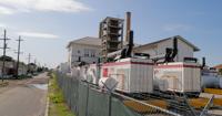
One of the four main turbines that power many of the Sewerage & Water Board's massive drainage pumps is offline as Hurricane Zeta menaces …
A hurricane watch was issued for New Orleans and a voluntary evacuation was called for areas outside the city’s levee system, where storm surge could be an issue.
Gov. John Bel Edwards issued an emergency declaration on Monday – his eighth of the year – in anticipation of the storm.
He expected Zeta to be mostly be a wind event. Winds of at least 30 mph and gusts of up to 70 mph are predicted for much of southeast Louisiana. Between 2 and 4 inches of rain is expected, and possibly more in some areas.
"The biggest threat as of now is damage from the wind," he told reporters. "We all need to be weather ready."
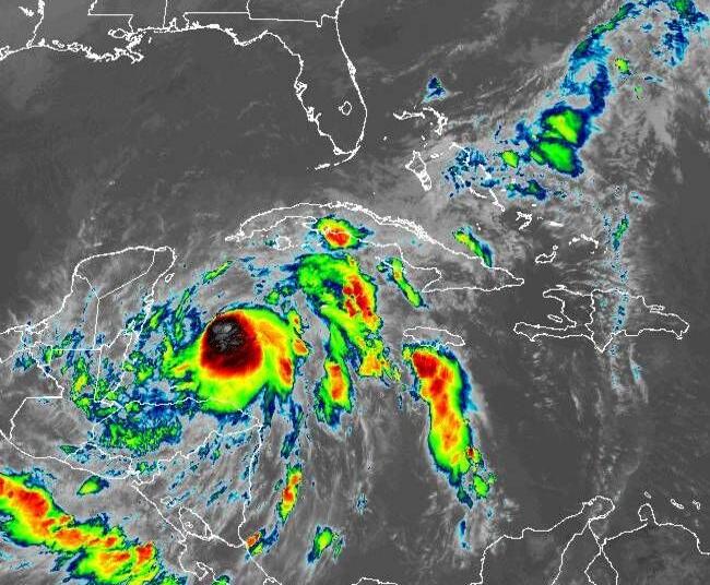
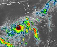
image via NOAA
But in New Orleans, rain may be a bigger concern due to a breakdown of a key power source for the city’s drainage system. Turbine 4 “unexpectedly went offline” on Sunday, according to the Sewerage & Water Board. It was undergoing inspection on Monday but would not be repaired in time for the hurricane, officials said.
The S&WB's turbines and generators are needed to power about half the pumps in the system, while the rest draw their power from Entergy. Turbine 4 is one of the largest power sources the utility has, providing up to about 18 megawatts of power.
Without it, the system can still generate enough electricity to run the pumps at full capacity and have some breathing room. But a breakdown in another turbine could mean power would have to be rationed during a severe storm, and areas that normally flood during heavy rain could take longer to drain.
Some neighborhoods flooded under 3 feet of water when Turbine 4 last failed, during a rain storm in June.
In a press briefing Monday evening, New Orleans Homeland Security and Emergency Preparedness Director Collin Arnold acknowledged the extreme activity of the season, saying "hopefully this is the last one, but I said that three hurricanes ago."
Still, he said he saw no signs that residents and emergency workers were letting weariness keep them from being ready.

Hurricane Zeta formed Monday, prompting some parish officials in southeast Louisiana to issue evacuation orders.
"We’ve asked them to do this so many times and surely we’re going to go through this again but people are listening," Arnold said.
"It’s been a pretty unprecedented hurricane season in the midst of a pandemic so people are hanging tough and we’re asking them to continue to do that through the end of hurricane season," he added.
New Orleans plans to lift parking restrictions at 6 p.m. on Tuesday to allow residents to park their vehicles on neutral grounds and sidewalks.
Sandbags will be distributed on Tuesday morning at the Dryades YMCA at 2220 Oretha Castle Haley Blvd., the Arthur Monday Center at 1111 Newton St., at the intersection of Desire Street and Law Street and at the Maria Goretti Church at 7300 Crowder Blvd. Sandbags are distributed on a first-come, first-served basis until each location runs out.
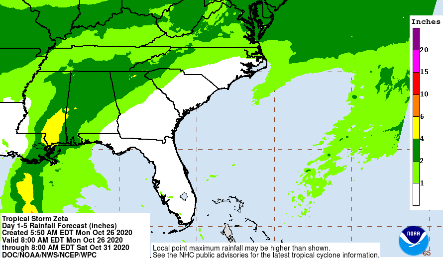
image via NOAA
No governmental closures in New Orleans have been announced, and trash collection is expected to continue as usual on Tuesday.
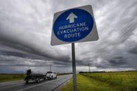
Mandatory evacuations orders along the coast got started with Grand Isle, which on Monday called for all campers, RVs and boats to leave the island as of 11 a.m. An island-wide voluntary evacuation goes into effect Tuesday morning.
Grand Isle's storm protection levee was damaged by Tropical Storm Cristobal in June. The levee has been patched with large sand sacks but not yet repaired.
Plaquemines Parish, which was at the center of Zeta’s forecasted path on Monday, began urging residents to prepare for storm threats and a possible evacuation.
“We’re looking like we might be close to the bullseye,” Plaquemines Parish President Kirk Lepine said. “Sad to say, but this has almost become routine for us. We’ve had so many storms this season.”

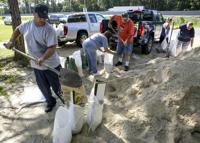
Ahead of Hurricane Zeta affecting Louisiana, local officials are putting out sandbag materials for the public to prepare.
Earlier this season, Hurricane Laura, Hurricane Delta, Tropical Storm Cristobal and Tropical Storm Marco all made landfall in Louisiana.
Zeta is the 27th named storm to form in the Atlantic this season. That ties 2020 with 2005, the record-setting year of storms that included hurricanes Katrina and Rita, for the most storms in a season. But 2020 likely isn’t done yet. Up to three more storms are possible before the hurricane season ends in late November.
Coastal communities are fatigued but well-rehearsed in their hurricane preparations.
“We’re doing what we know how to do so well now, and that's to be prepared,” said Chett Chaison, executive director of the Greater Lafourche Port Commission. The commission manages Port Fouchon, the service hub for most of the offshore oil and gas production in the northern Gulf of Mexico. For the first time this hurricane season, Fourchon looks like it may take a direct hit. But a Catagory 1 shouldn’t trouble the port too much, Chaison said.
“We expect some surge, but nothing catastrophic,” he said.
The port may evacuate, but its nearly 200 vessels will remain staffed in case of mooring breaks and other emergencies.
Edwards said he is grateful Zeta is not headed for southwest Louisiana, especially after powerful hurricanes Laura and Delta struck less than 20 miles apart.


Restoration projects along Louisiana’s coastline were mostly spared by the six different hurricanes that have threatened the state so far this…
Laura upended the lives of thousands of citizens, with widespread power outages and the loss of running water.
The New Orleans area was squarely in the line of Hurricane Sally until it veered east and struck Alabama in mid-September.
Edwards said Louisiana residents should keep a close eye on Zeta’s path in case it, too, takes an unexpected swerve.
"Please don't let your guard down," he said.
-Staff writers Jeff Adelson and Will Sentell contributed to this report.


Just as Louisiana begins an ambitious slate of projects to rebuild its crumbling coastline, the essential ingredients — sea sand and river sil…
U.S. - Latest - Google News
October 27, 2020 at 06:20AM
https://ift.tt/37IE3A0
Hurricane Zeta to become 5th named storm to hit Louisiana in unprecedented season - NOLA.com
U.S. - Latest - Google News
https://ift.tt/2ShjtvN
Shoes Man Tutorial
Pos News Update
Meme Update
Korean Entertainment News
Japan News Update
Bagikan Berita Ini


0 Response to "Hurricane Zeta to become 5th named storm to hit Louisiana in unprecedented season - NOLA.com"
Post a Comment